Prepared by Ignacio Armillas/Heinz Kull/David Lewis/Gunnar Wiessner
CHINA: Rebuilding After the Floods of 1998
[The following is a summary of
the mission report prepared by a UNCHS (Habitat) post flood evaluation
mission undertaken to Jianxi and Hubei provinces in November-December
1998.]
Summer
floods along the great rivers of China have been an annual occurrence
for millennia. Residents have adapted to this phenomenon, capturing
the benefits while allaying the negative consequences. The fertile
plains along the rivers and associated lakes have supported high
levels of agricultural productivity, providing the foundation
for development of the Chinese civilization.
The floods of 1998
In
recent decades population pressure and industrial development
have caused settlements and economic infrastructure to be built
in low laying areas vulnerable to inundation. The need to expand
acreage for food production has also stimulated land reclamation
from lakes and other flood surge catchment areas. Strategies to
reduce the effects of seasonal floods have focused on large scale
engineering efforts such as the dams and embankments. In the short
term these structures help manage seasonal flooding. But in the
long term, such capital intensive approaches can be questioned
on both cost-effectiveness and environmental grounds. Over time,
they tend to exacerbate the impact of floods by accelerating the
siltation of river channels and lakes, reducing the natural surge
absorption capacity. High water levels vary from year to year.
While flood protection measures can be designed for a particular
water level, these levels may be exceeded during periods of extraordinary
flow, and 1998 was such a year. Due to a combination of factors,
unusually high levels occurred in the north-east, along the Songhuajiang,
Nenjiang and other rivers, and in the central and southern parts
of the country along the Yangtze and its tributaries.
The Ministry of Civil Affairs
reported that about 230 million people were affected by the floods,
and as many as twenty million people were displaced. Seven million
houses were totally destroyed, and thirteen million damaged and
in need of repair. Fifteen million farmers lost their crops contributing
to a total direct economic loss estimated to exceed US$ 32 billion.
Excellent early warning systems and prompt response by the government
kept the death toll to 3,656 people, an extraordinary accomplishment
considering the immensity of the floods. Provincial authorities
stated that the 1998 disaster was worse than the floods of 1954,
perhaps the worst natural ever in terms of the number of people
affected. 
UNCHS (Habitat) Assistance
In response
to the flood, the national government worked closely with provincial
and local governmental bodies in mounting a major reconstruction
initiative. As part of the effort, the United Nations Centre for
Human Settlements (HABITAT) was requested to provide technical
assistance in planning the program. This assistance took the form
of an international team that worked in the flood area in December
1998. (The authors of this paper were members of the team.) They
were requested to provide advice on the reconstruction program
and make specific recommendations for demonstration projects.
In the northern part of the country the
early onslaught of winter made it imperative that the government
help construct shelter for the displaced population and provide
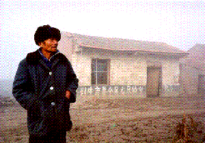
emergency winter supplies. In some cases temporary "pit houses"
were being used. In the southern parts of the country there was
more time to plan and carry out rehabilitation and reconstruction
before the onset of cold temperatures. The same needs, however,
are being felt, and tents were being provided for temporary shelter.
The team visited
two of the most affected provinces in central and southern China,
Hubei and Jiangxi. All of the sites examined were rural and particularly
vulnerable to seasonal flooding. Village rehabilitation and relocation
initiatives were well under way in both regions.
In Hubei Province, the flood
took its worst toll in those areas which had previously served
as natural flood plains for the Yangtze river and its tributaries.
The farmlands along the river, and its associated tributaries
and lakes, have been protected by thousands of kilometres of dikes.
Over time, however, the building up of the river banks has led
to silting that has caused the level of the river beds to rise,
which in turn has lifted the level of the river surface requiring
ever higher levees. The result has been that the river in many
areas, even under normal conditions, is higher than the surrounding
countryside. When flow rates are increased by heavy rains as were
experienced in the summer of 1998, the dike and levee systems
could not contain the water, and wide-spread flooding followed.
In Jiangxi Province
most flooding took place in areas surrounding Lake Boyang. Extensive
land reclamation in recent decades has considerably reduced the
lake's surge storage capacity. In 1954 this lake had a surface
area of 5,100 square kilometres. and a capacity of 37 billion
cubic metres, by 1997 the surface had been reduced to 3,900 square
kilometres and the capacity to 29.8 billion cubic metres.
Government Programs
The
central government provides guideline policies and coordinates
rehabilitation work after disasters, while the provincial and
local governments carry out the reconstruction work. In the case
of the floods of 1998, the Ministry of Civil Affairs is the lead
ministry for rehabilitation of villages and towns, while the Ministry
of Construction is responsible for the village relocation projects
and infrastructure works. This Ministry formulates general guidelines,
while the specific layout plans for the new villages are prepared
at the provincial level by professional planning and design institutes.
The government
has established a policy that recovery efforts should not simply
restore the affected areas to their pre-disaster condition, but
should aim at improved living conditions for the population, and
should support complementary development initiatives. Furthermore,
reconstruction and rehabilitation should take place in the original
location of the settlements whenever possible. Only in exceptional
cases where the original settlement was located in a high risk
area (e.g., lowlands next to a river, or islands in the river
which require major protective embankments that would have significant
impact on the natural flow of the waters), or in areas to be reclaimed
by rivers channels or lakes will settlement relocation be considered.
Based on this overall policy the government's objectives are:
Expand flood
reception capacity;
Reduce risk to life and property;
Improve the living conditions of victims; and
Stimulate economic development
with emphasis on the industrial sector.
The first and second objectives relate to
the encroachment of human activity and settlement in natural flood
surge absorption areas along rivers and lakes. Those uses of such
areas that place human life or major investments at risk will
be discouraged.
The
reduction of natural flood plain areas over the last several decades
contributed significantly to this year's massive floods. Consequently,
the government intends to restore these areas to function in their
former capacity. Farming and similar activities can, and will
be allowed to take place, but human settlements located in these
areas will be relocated. In Jiangxi province, for example, the
government intends to restore Lake Poyang to its pre-1954 capacity.
This will require that villages located on reclaimed lake land
of less than 22 metres elevation (above sea level) be relocated
to higher ground. In Hubei province, settlements on low islands
or shores without protection of the main dike system of the Yangtze
River will also be moved to higher ground or to locations behind
the dike.
The
third objective is one frequently absent in post-disaster rehabilitation
programs. Often government, and donors, seek only to restore conditions
to those prevailing before the disaster, forsaking the opportunity
to make improvements when rehabilitation has to be done anyway.
The last objective
pertains to the development of new sources of employment in rural
areas. This is important throughout the country since the agricultural
sector will require less workers as it modernizes, and alternative
sources of employment will have to be available in rural areas
if population is not to leave those areas. This factor is particular
significant in villages that are being relocated because their
land reverted to the lake.
By December 1998, the government had already selected
the new sites for those villages to be relocated. This was done
on the basis of regional development plans and detailed site studies.
In some cases the population of villages being abandoned will
be integrated into existing villages or towns, expanding the settlement
area and upgrading services such as schools and clinics. In other
cases the villages will be relocated to new places. Villages where
the inhabitants are expected to continue working their original
farmland are being relocated within a "comfortable distance
from the new village to its fields." "Comfortable distance"
is considered to be a maximum of five kilometres.
Although only a relatively
small number of affected villages will be relocated, the government
is giving these settlements high priority, because they are the
villages at high risk of future flooding. In line with this policy
the benefits for families in relocated villages are more generous
than those for families in villages that are simply being rehabilitated.
The financial allowances offered by the Government for housing
to each family in a relocated village are:
Cash payment ranging from 10,000 to 15,000
Yuan (approx. US$ 1,200 to 1,800) Government guarantee of credits
for building materials; and
Tax exemptions.
The cash grant is sufficient
to cover a major portion of the costs of constructing 80 square
metres at ground level. The rest of the costs are to be covered
by each family from their own savings, and by borrowing from small
credit facilities and relatives. The government is also providing
a credit guarantee that covers the cost of additional building
materials.
The
Government will provide social facilities and municipal services.
However, except for a few model villages, the Government can only
afford to build some schools and clinics. For the time being infrastructure
for municipal services is not being provided.
In the case of villages that are to be rehabilitated
in their existing sites, the cash grant provided by the Government
for house repair or reconstruction is much smaller than that for
house replacement in villages being relocated. Additional resources
are provided by provincial and county governments, with the balance
to be covered by the beneficiary. 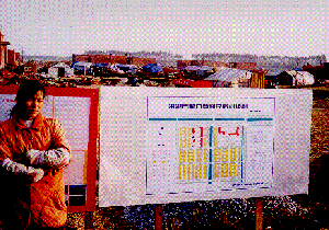
Village Planning and
Construction
In
most cases, plans for the relocated villages were prepared by
the local county, city and/or provincial planning institutes (guihua
shejiyuan). In a few villages, the plans were centrally prepared
by the China Academy of Urban Planning and Design (zhongguo
chengshi guihua sheji yanjiuyuan) in Beijing. In at least
one case, the village of Huangpojing, Jiangxi province, parts
of the new settlement plan were designed by the villagers themselves.
This was done as an emergency action immediately after the floods
to ensure an early start of there construction at a time when
the over-stretched governmental planning agencies were unable
to attend the planning needs of all the affected settlements.
The designs
for new settlements are highly symmetrical. In all the plans reviewed
by the HABITAT team the layout was that of a grid of straight
streets intersecting at 90 degrees. This configuration appears
to be favoured by the communities as it allows for the orientation
of the buildings along the traditional north-south axis. The symmetrical
lay out should also facilitate the future provision of water and
sanitation infrastructure. Within any village, the houses all
have the same setback from the road. The structures are paired
so that two units share a common wall to save building materials
and land.
The
government's rehabilitation strategy is particularly noteworthy
for the involvement of community leaders and officials in the
process, and for the support of self help initiatives. Although
the general guidelines and a good part of the resources come from
the central government, the rehabilitation plans are prepared
by professional institutes at the provincial level and drawn in
close consultation with county authorities and the communities.
According to reports obtained from the communities, this consultative
process has worked well. Villagers explained that the planning
teams had met with them several times in their old villages.
In all the sites
visited by the team, the villagers reported that the plans had
been presented as draft versions at public meetings. In cases
where the future residents suggested changes to these drafts the
recommendations were taken into account by the planning department
in finalizing the layouts. The villagers in Baotacun, Hubei province,
for instance, reported that the draft plan originally had shown
a more heterogeneous layout design of the settlement. Apparently
the design team had tried to suggest a settlement structure that
allowed a stronger emphasis on aspects of individuality. However,
this plan was not approved by the people. Instead, they suggested
a general orientation of all buildings according to the traditional
north-south axis of Chinese farm houses. As a result, the final
plan approved by the people shows the typical highly symmetric
design. The villagers also asked for a reduction of the space
occupied by the whole site in order to retain more farmland. This
suggestion was accepted by the planning team, and is reflected
in the relatively narrow layout of the final design.
Housing plots in the relocated
villages were generally distributed among the villagers through
a public lottery. Everyone seemed satisfied with this system.
In some cases, villagers reported that after the lottery, individual
families had traded lots by mutual agreement.
Depending on the size and architectural complexity
of the new site and its buildings, the degree of technical expertise
required for construction varied from location to location. In
general, the new buildings are either built by the villagers themselves
or by licensed construction workers who had undergone a short
training course provided by the construction department at the
county or provincial level. Technical assistance during the construction
phase was provided by resident advisors supplied by the provincial
governments. To reduce costs, the villagers undertook all the
unskilled work such as the transportation of building materials
to the construction sites, and the mixing of cement and mortar.
All members of the household helped.
The dwellings are being built of traditional
construction materials--bricks, stone, and cement. The local residents
in the areas pointed out that they not only find these materials
acceptable and know how to build with them, but by using the same
materials as they had in the past, it was possible to recycle
the bricks and stone from the destroyed buildings.
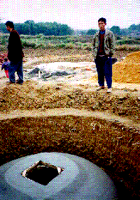
Infrastructure
None
of the relocated villages visited was connected to a public water
supply or sewer system. According to information obtained from
the local governments, the connection of the new villages to water
supply systems, though planned, is not envisaged in the near future
due to financial constraints. Water for the relocated villages
will therefore be provided in the same way as in traditional villages
with each family having its own shallow well in the backyard.
The lack of
attention to the water and sanitation is not due to a lack of
awareness on the part of responsible officials. It is a question
of priorities and resources. The highest priority is the provision
of shelter. After the need for housing is addressed, there will
be few resources left for other priorities including schools and
health facilities. Thus, the provision of water and sanitation
will have to wait, or be left to individual villages to resolve
on their own.
All
new settlements are currently accessible by unpaved roads. These
are tracks that have been built to provide access for construction
vehicles access to the site. they may not be the most efficient
in terms of providing the villagers with access to their agricultural
land, schools, and markets. Also, these roads may not be passable
during the rainy season. 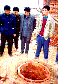
Conclusions
The
government policies and programs for village rehabilitation/relocation
are compelling. Progress with implementation is impressive. Locational
factors are being taken into consideration, and plans for the
new villages are well done, with the communities participating
in the process. The houses are more than adequate in terms of
space and quality of materials being used, and the designs seem
to reflect the cultural preferences of the population.
The next immediate need is
for social service facilities such as schools and clinics. Simultaneously,
water, sewerage, and road infrastructure will have to be installed.
(Electricity is already available in most sites.)
Looking ahead, the government
may wish to develop the employment generating potential of the
construction industry, particularly in the flood-affected areas.
The current building activity has been accelerated to create the
minimally needed accommodation as quickly as possible. Virtually
all of the new dwelling units will require further construction
before they are completed. Skilled construction workers are going
to be in demand. They will also be needed for the schools and
clinics that will be built, and the water, sewerage, and road
infrastructure that will be installed. Government training programs
emphasizing new techniques and quality control would be particularly
productive.
The
availability of infrastructure will help integrate the villages
with local, regional, and national economic structures, and facilitate
the development of local employment opportunities.
1. Dr. Ignacio Armillas (Team Leader)
Director, UNCHS (Habitat) Fukuoka Office
Fukuoka, Japan
2. Dr. Heinz Kull (Disaster Management Specialist)
Coordinator, Disaster Management Programme
UNCHS /Technical Cooperation Division
Nairobi, Kenya
3. Dr. David Lewis (Resettlement Consultant)
Professor, Department of City and Regional Planning
Cornell University
Ithaca, New York, USA
4. Dr. Gunnar Wiessner (Community Development Expert)
Junior Professional Officer, UNCHS
Bangkok, Thailand
5. Mr. Gong Weiping (Planning Expert)
Planner, Center for Administration of National and Urban Planning
Ministry of Construction
Beijing, China
6. Mr. Li Qiang (Planning Expert)
Senior Urban Planner, Department of Rural and Township Design and Planning
China Building Technology Development Corporation
Beijing, China
Representatives from the Ministry
of Construction
1. Mr. Zheng Wenliang (Coordinator with local authority)
Senior Engineer, Department of Urban and Rural Planning
Ministry of Construction
Beijing, China
2. Mr. Eric Yao (Coordinator)
Program officer, Department of International Relations
Ministry of Construction
Beijing, China
Notes: This paper appears in the Volume IV of "The Current", the public policy journal of the Cornell Institute for Public Affairs